

Project Description
NUNAVUT
Devon Island in the High Arctic
Haughton Meteorite Impact Crater created in the early Miocene; Cambrian to Devonian strata of Arctic Platform
fieldwork by Ray Thorsteinsson
THE SCIENCE
As indicated previously, Bruemmer’s photograph was taken looking north along an unnamed river draining into Thomas Lee Inlet, on the north coast of Devon Island. As there are two rivers that flow into the southernmost end of the Inlet, we are left to speculate exactly where it was taken.
The weight of evidence would suggest the northerly of the two rivers in question, with the picture taken close to the river’s mouth. This placement is shown on the accompanying geological map by a red arrow.

Haughton geological map
The river side cliffs would then be assigned to more resistant beds of the Middle Ordovician age, Bay Fiord Formation (OCB).
Devon Island was the subject of a thorough geological study by the GSC with field work being carried out in the years 1976, 79 and 80 under the leadership of Ray Thorsteinsson along with his colleagues Ulrich Mayr and Thomas Frisch.
The map, illustrated in part here (Map 1), was authored by Thorsteinsson and Mayr and published in 1986.

Map 1: GSC geological map of NW Devon Portion of geological map sheet (Bear Bay West Map 1614A) by Thorsteinsson (1986).
Inset map indicates the portion of Devon Island covered, the Haughton Astrobleme (yellow circle), and also the route taken by the artist Fred Bruemmer on his dog sledge trek in 1968.
The map is dominated by two features. The vertical (north-south) colour striping represents different geological formations as they are exposed at the surface. The strata making up the formations have a gentle and relatively uniform structural dip of about 4o towards the west, with the youngest formations of early Devonian age (Sophia Lake Formation –DSL) being exposed in that direction. The oldest strata seen in this cropped view of the map is the Cambro-Ordovician Cass Fjord Formation (COCF).
The total thickness of strata represented on this portion of the map is approximately 3.3 km. Although each formation is lithologically distinct, they are all dominated by carbonates (limestones and/or dolostones) with subordinate amounts of evaporates, shales, and fine-grained silts and sandstones, representing deposition on a stable, moderately-subsiding, attached carbonate platform.
A great variety of deep shelf to peritidal to shallow estuarine and strand plain paleoenvironments can be interpreted in this thick succession. This part of Devon Island is part of a widespread geologic province referred to as the Arctic Platform.
The second striking feature is the predominantly yellow 24 km diameter circular feature surrounded by semi-concentric dip-slip faults, that occurs superimposed on the outcrop belt of the late Ordovician tolate Silurian age, Allen Bay Formation (OSA). This circular feature is known as the Haughton Astrobleme and represents the eroded remains of a major meteor impact crater of early Miocene age.
-
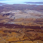
- The haughton crater (Astrobleme)

-
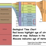
- Geological Time chart showing Miocene Period

-
- Miocene paleogeography

Large scale meteor impact craters are rare, firstly because significant collisions between asteroids/comets and Earth are extremely rare, but also because the forces of erosion, post-impact sedimentation and/or subduction tend to hide or obliterate such features.
The Haughton structure has thus received a considerable amount of study. Furthermore its location, desolation, terrain, harsh climate and geological features indicative of impact, have proven to be a very useful field site for testing astronauts and space equipment, and Haughton has been called the closest thing on Earth to Mars.
In 1978 Tom Frisch and Ray Thorsteinsson published a short paper on the structure, relabeling it the Haughton Astrobleme. It was first recognized from aerial photographs and in 1955 field work by Greiner (1963) led to the conclusion that is was possibly an evaporate diaper.
-

- Haughton Astrobleme – Astronaut Testing Site

-
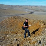
- Eroded hydrothermal pipe structure

-
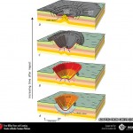
- Haughton Crater: Generalized sequential model for large bolide impacts

It was not until 1972 that its possible origin as an impact crater was postulated, and not until 1976 when evidence in the form of shattercones were identified on site.
-
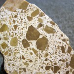
- impact breccia

-
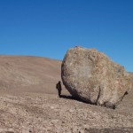
- Ejecta block

-
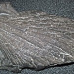
- Haughton Astrobleme: shattercones

The work by Ray and Tom:
- Confirmed this interpretation by identifying shock metamorphic minerals (coesite) within impact breccias clasts of Precambrian basement gneiss
- Identified the most likely age of the impact based primarily on the absence of Eureka Sound Formation deposits, and preliminary age determinations of post-impact lacustrine sediments within the crater
- Determined that the depth of impact must have reached a minimum of 1700m based on ejecta and remnant formations brought to surface.
Select References
- Bruemmer, F. 1969 The Long Hunt, Ryerson Press, Toronto, 152pp., 61 plates.
- Bruemmer, F. 2005 Survival: a refugee life, Key Porter Books, 270pp.
- Bruemmer, F. 2008 Arctic Visions, Key Porter Books, 279pp.
- Frisch, T. & Thorsteinsson, R. 1978 Haughton Astrobleme: A mid-Cenozoic impact crater, Devon Island, Canadian Arctic Archipelago. Journal of Arctic Institute, v. 31, p. 108-124.
- Thorsteinsson, R. 1986 Geology, Bear Bay West and Baillie-Hamilton Island, District of Franklin, Northwest Territories; Geological Survey of Canada, “A” Series Map 1614A
- Thorsteinsson, R. & Mayr, U., 1987 The sedimentary rocks of Devon Island, Canadian Arctic Archipelago. Geological Survey of Canada, Memoir 411, 182 pp.
