Project Description
NUNAVUT
Bylot Island
Archean high-grade meta-sediments, volcanics and granites intruded by slightly younger monzonite (Bylot Batholith)
fieldwork by Albert Peter Low
THE SCIENCE
Bylot Island (Map 2) is the 71st largest island in the world and lies north across a narrow sound from Baffin Island (the 5th largest island in the world), on the northeastern edge of the Canadian Shield.
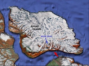
Map 2: Satellite image of Bylot Island in the summer showing the extensive ice cap and glaciers. Blue arrow points to Mount Thule and the red arrow indicates approximate vantage point for the Harris painting.
It was named after Robert Bylot, first mate on Henry Hudson’s ship. Bylot later returned to the area as captain of the Discovery, accompanied on one of his voyages, as pilot, by William Baffin, who gave his name to Baffin Island.
Bylot’s account of his exploration was not initially believed, and his charts were dismissed. Two centuries later, when explorers such as Parry reached as far north, the validity of Bylot’s maps were confirmed.
Bylot Island lies on the north west edge of the Canadian Shield, the largest area of Precambrian rock in the world. Roughly two-thirds of Bylot Island exposes these ancient rocks and all of the mountainous terrain depicted in the Harris landscape is made from rocks originally formed 2.5 to 2.9 Ga (billion) years ago.
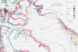
Map 1: Portion of geological map by A.P.Low, published in 1906, showing the geology along the route of the Neptune (1903-04). The coast of Bylot Island was interpreted by Low to be entirely Archean in age.
By contrast the current topography has been sculpted by much, much younger glacial forces that started their work only 2.5 Ma (million) years ago, and are still very much in operation today. The geology of a small coastal portion of the island was cursorily examined by Low (Map 1).
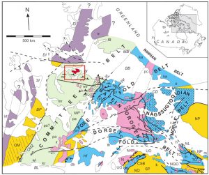
It remained unstudied until the 1950’s, and most notably it was the subject of reconnaissance bedrock mapping in 1965 and again in 1973-1974. The island lies within two intersecting geological provinces (Map 3).
The Committee Belt is a NE-SW trending zone up to 500 km wide, of highly metamorphosed (intensely altered by heat and pressure), mostly Archean-age granites, volcanics and sediments.
The Belt runs from the SW through the northern end of Baffin Island and on to Greenland. The second province is termed the Baffin Orogen. A structural element of this province (the Northeast Baffin thrust belt – NBTB on Map 3) extends to the northwest and affected the rocks of Bylot Island, during a period of folding, southwesterly-directed thrust-faulting, and intense metamorphism around 1.81-1.82 Ga.
The Harris painting depicts the Sermilik Glacier as it reaches the waters of Eclipse Sound (the Arctic Ocean). In the background is a portion of the Byam Martin mountain range, with the ice and snow-covered peak of Thule Mountain in the centre of the view. The rocks forming the mountains can be placed in 2 broad groups.
The oldest of these are intensely metamorphosed, volcanics, granites and sedimentary rocks. Marginally younger are metamorphosed granites that form a broad U-shaped outcropping of rocks, referred to as the Bylot Batholith.
This ancient intrusive body dominates the geology of the island. Geoscientists can ascertain the age of a rock if it contains sufficient (albeit small) amounts of specific naturally occurring radioactive elements whose rates of decay are known. Such elements (like uranium) and the stable by-products of their decay (daughter elements) are often concentrated in certain minerals such as zircon.
Furthermore, it is possible to make an estimate of the pressure and temperature at which a rock has been altered (metamorphosed) as it is buried deep in the Earth’s crust, by examining which groups of minerals co-exist together in the same rock.
It is through these investigations that we know that the older rocks of Mount Thule formed about 2.7 billion years ago and were subsequently metamorphosed at high temperatures and pressures deep below the Earth’s surface.
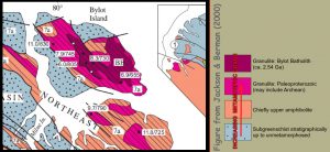
Map 4: Metamorphic Facies of Bylot Island. Metamorphic grade (see legend) increases towards U-shaped Bylot Batholith
The younger granites (the technical name for this particular type is charnokytic monzonite) were emplaced around 2.55 Ga but were then further altered (metamorphosed) at temperatures of 730 to 805o C under pressures of up to 8 kilobars (Map 4).
Modern Glaciation
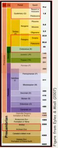
Time Scale showing Geologic Periods. Time shown on right as millions of years before present scale is not linear; red boxes enclose ages of rocks exposed on Bylot Island.
At the present time, about 40% of Bylot Island is covered by ice, and sediments that are associated with glaciation such as moraines. A considerable amount of field work has been carried out in recent years on the study of these comparatively recent deposits.
This research has indicated that the glaciers have retreated 1 – 2 km in the last 120 years and that the ice cover has decreased by about 5% in the last 40 years. Nonetheless there are indications of occasional surge growth of some of the glaciers.
Further Reading and References
- Eyles, N. & Miall, A. 2007 Canada Rocks: The Geologic Journey, Fitzhenry & Whiteside, 512pp. Finkelstein, M. & Stone, J. 2004 Paddling the Boreal Forest.
- Jackson, G.D. & Berman, R.G. 2000 Precambrian tectonic and metamorphic evolution of northern Baffin Island, Nunavut, Canada. The Canadian Mineralogist, p.399-421.


 Albert P. Low