

Project Description
QUEBEC
Saguenay River area
Exposed roots of Precambrian mountains; development of Saguenay Graben; Pleistocene glaciation and isostatic rebound
fieldwork by Joseph Kemner Laflamme
THE SCIENCE
At the beginning of his involvement with the Royal Society of Canada in 1882, Laflamme got to know the researchers at the Geological Survey of Canada (GSC). It was at one of these meetings in 1883 that he met Alfred Richard Cecil Selwyn. Selwyn, then director of the GSC, asked Laflamme to study the region of the Saguenay and Lac Saint-Jean. It was from this moment forward, that Laflamme started his long years of exploration and geological mapping.
During the course of this period he covered the Saguenay and Lac Saint-Jean sectors but also worked the north shore of the St Lawrence River from the Saint-Maurice River to Anticosti Island, which he visited in 1901.
The reports stemming from his work were published by the GSC and the Royal Society, and constitute the main body of his scientific output. We can detect within his writings a great analytical rigor as well as a marked interest in describing and explaining natural phenomena and the geological forces that formed the landscapes of today.
His studies included the rockfalls and landslides found in Quebec, the gold deposits of the Beauce, and the natural gas seeps in the region around Louiseville.
Interpretation
In one of his reports, Laflamme wrote to A.R.C. Selwyn “ I believe that I am in a position to provide to you several new observations that, to a certain degree, will modify the geological map of the region of the Saguenay published by Sir William Logan in 1863.”
Laflamme indicated that the Precambrian Laurentian Shield (“Laurentides”), in the regions explored, consist of an assemblage of two distinct series. Firstly, one finds hornblendemica gneiss near Chicoutimi, Sainte-Anne, Lake Kenogami and on a certain portion of the shoreline of Lac Saint-Jean. Secondly one finds larges masses of labradorite concentrated in the region of Alma and in the eastern parts of Lac Saint-Jean.
Laflamme noted that the series composed of gneisses is associated with large bands or beds of quartz and feldspar that are oriented perpendicular to the river. He emphasized that these bands probably indicate a primary stratification, although in certain cases, they had been strongly contorted and had the appearance of veins or dykes. In all cases they appeared to Laflamme to be (largely) contemporaneous with their host.
Laflamme also remarked that these rocks testify to the effect of weathering that attacks the bedrock selectively. A good part of the surfaces initially polished and rounded by the passage of glaciers is now rough. Bands of quartz and other minerals are left in high relief whereas less resistant minerals are eroded to a greater or lesser extent. Laflamme underscored the fact that the geomorphology of the rock indicates, by the rounded surfaces of outcrops on their northern flank, and rough surfaces on their southern, the direction of movement of the glaciers from the north to the south.
The rocks of the labradorite series were described by Laflamme to be of a dark brown colour with a touch of blue. He further observed that these compact hard rocks contain large crystals of feldspar in which one sees the typical plagioclase twinning.
In addition Laflamme indicates that one finds ilmenite in certain places, an observation omitted by Logan.
The economic minerals that Laflamme identified in the Laurentian Shield were mica, antimony-based sulphides and an agglomeration of minerals distributed along the length of the road towards Kaskouia, consisting of garnets and emeralds.
GENERAL GEOLOGY OF CAPE TRINITY AREA
Current geological knowledge permits the attribution of the development of the Saguenay fiord to three events. The first, that occurred more than 950 Ma ago within the Precambrian, is the rise and deep erosion of the Laurentians, such that today all that remains are the roots of former mountains composed of gneiss and granitic rocks.
The second is the creation of two parallel faults, that were active between 190 and 175 Ma, that determined the formation of the Saguenay graben.
Finally the glaciations of the last million and a half years carved a Ushaped valley along the length of these two faults. At the melting of the glaciers, which had achieved a thickness in excess of 3km, the sea invaded the region to a height of 150 to 200m. Finally, isostatic rebound, caused by the removal of the glaciers, has brought the land to its present height.
The topography of the sector is quite varied. Generally the cliffs surrounding the fiord are between 150 and 300m, but attain a maximum height of 412m at Cape Trinity. Here the rocks are composed of an intrusion of porphyritic mangerite.
This area represents a junction point between two important structures: the regional NW-SE faults responsible for the collapse of the Saguenay graben, and a large NE-SW wrench fault by which the Trinity River emerges on the right bank of the Saguenay. This intersection of two major structures (inherent planes of weakness) was a place where agents of erosion, like ice, water and wind, could maximize their impact, making the creation of Cape Trinity possible.
Another Interpretation
According to a legend from the Montaignais first nations, Cape Trinity is the result of the combat between Mayo, the very first Montagnais, and a fierce and malevolent manitou (evil spirit). While he walked by the river a fierce creature emerged from the water to attack him. Mayo could only respond with his courage, and he grabbed the creature by its tail and swung it against the mountain. It was on the third blow that the beast was finally subdued which explains the three levels to the Cape. Ever since, vegetation has never grown on this place.
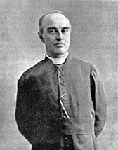 Joseph-Clovis-Kemner Laflamme