Project Description
SASKATCHEWAN
Southwest Saskatchewan On Southern Flank of East Block of Cypress Hills
remote sensing; Cretaceous-Tertiary (K-T) extinction event; dinosaur finds
fieldwork by Richard McConnell and Jack Mollard
Southwest Saskatchewan – THE GEOSCIENCE
Kerr’s painting of the Ross Ranch is set in southwestern Saskatchewan on the southern flank of the eastern block of Cypress Hills, west of Eastend.
This area was first mapped by R.G. McConnell. McConnell’s 1885 map depicts the distribution of Tertiary and Cretaceous strata which, except in the highest parts of the Cypress Hills, and parts of the Wood Mountain area in the eastern portion of his map area (not shown here), are covered by glacial sediments of varying thickness.

Figure 1: Portion of GSC map by R.G. McConnell published in 1885. Yellow circle depicts area of Ross Ranch painted by Aubrey Kerr.
The composition, origin and distribution of these sediments are shown on the southwestern portion of the 2002 Saskatchewan Geological Highway map (upper right), as is the distribution of exposed bedrock.
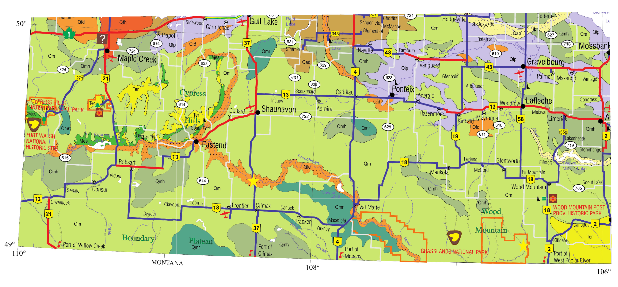
Figure 2: Portion of Saskatchewan Geological Highway Map (2002) showing that the area in this part of the province is dominated by Quaternary sediments. Ross’s Ranch is shown by purple circle.
The NASA Landsat 7 image, captured during the summer of 2000, provides a snapshot of a portion of McConnell’s map. The original image uses primarily reflected infrared light, providing valuable information about the Earth’s surface not visible to the unaided eye. Grasslands appear as extensive areas of green and magenta tones depending on density of vegetation cover. The densely treed areas in the Cypress Hills appear as very dark green. Farmland appears as a fine grid pattern due to cultivation patterns on fertile soils developed on glacial deposits.
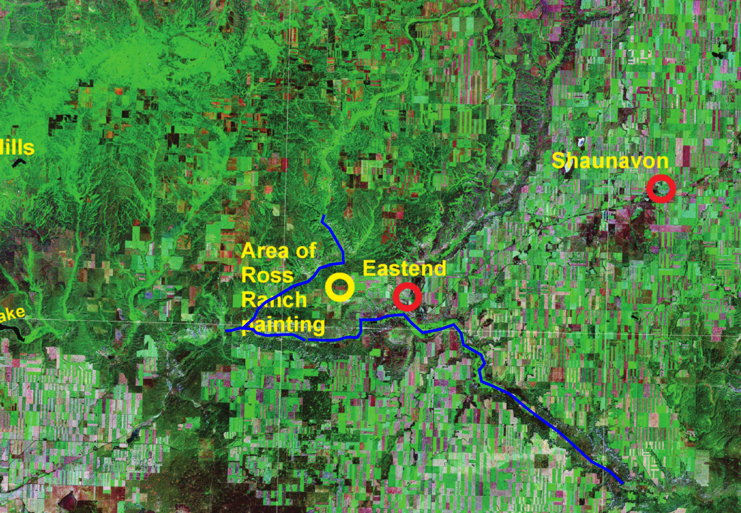
Figure 3: NASA Landsat 7 Satellite image (Summer, 2000)
The location of the area depicted in Kerr’s painting of the Ross Ranch is marked by a purple circle on McConnell’s map, and on the Landsat image. The annotated Google Earth satellite image (adjacent) provides a close-up view of the area of the painting.
The Interpretation
Kerr’s painting of the cabin and barn at the Ross ranch was done looking south into the Frenchman River valley (called the White Mud River on Kerr’s 1885 map). The Google Earth satellite image provides a present-day snapshot of this view. Exposed on the hills in the Kerr painting and on the Google Earth image are interbedded Cretaceous sandstone, siltstone and shale strata that are 67 to 70 million years old. Top beds are characterized by greyish to almost pure white clay and sand (McConnell’s “white mud” beds).
 from the area portrayed in Kerr’s painting. Hills in the background are the Bearpaw Mountains in northern Montana.")
Figure 4: Satellite image (courtesy of Google Earth) from the area portrayed in Kerr’s painting. Hills in the background are the Bearpaw Mountains in northern Montana.
In his 1885 report, McConnell wrote that exposures of this unit “in the distance look like great white snowbanks.” McConnell describes the underlying strata as “yellowish sands.” A layer commonly exposed along the base of some valley sides is composed of “lead-grey and dark shales.”
East of the abandoned Ross ranch site, Upper Cretaceous strata (~65 to 66 million years old) have yielded dinosaur fossils, including the well preserved skeleton of a Tyrannosaurus rex nicknamed “Scotty”, and the skull of a Triceratops prorsus.

Figure 5: “Scotty”s teeth in place in T. rex quarry. Photo courtesy of Royal Saskatchewan Museum.

Figure 6: Skull of Triceratops prorus. Photo courtesy of Royal Saskatchewan Museum.
Tertiary strata (65 to 11 million years old) are exposed locally northwest of the area depicted in Kerr’s painting. Cemented Tertiary sandstones and conglomerates cap the Cypress Hills Upland. Smoothly rounded pebbles and cobbles, which are commonly seen on the surface, were derived from uplifted highlands in Montana and transported north to southwestern Saskatchewan as part of a massive braided river system (Leckie and Cheel, 1989). This hard, cemented layer provided protection from later erosion and preserved the Cypress Hills as a dissected plateau. Interestingly, the highest point (1466 m) between Labrador and the Rocky Mountains is found in the Cypress Hills along the Alberta-Saskatchewan boundary.
The K-T Boundary
The Cretaceous-Tertiary (K-T) boundary in Saskatchewan and elsewhere in the world coincides with a thin iridium layer associated with the Chicxulub meteorite impact in the Yucatan Peninsula, 65 million years ago. The K-T boundary is well-documented at two sites in southwestern Saskatchewan: south of Shaunavon on Highway 37 on the north side of the Frenchman River Valley, and in the east block of Grasslands National Park west of Kildeer (yellow stars on geological highway map). In both locations, the boundary occurs at the base of a Paleocene coal seam overlying upper Cretaceous sands, siltstones and shales. Extermination of about 50% of all species of plants and animals on Earth, including the dinosaurs, is associated with the K-T boundary. Many researchers support the theory that the Chicxulub impact was directly and indirectly responsible for this extinction.

Figure 7: K-T boundary, Zahurski’s point, Grasslands National Park. Photo courtesy of A. Sweet, GSC Calgary
References
Leckie, D.A. and Cheel, R.J., 1989, The Cypress Hills Formation (upper Eocene to Miocene): a semi-arid braidplain deposit resulting from intrusive uplift, Can. J. Earth Sci., v26, p.1918-1931.
McConnell, R.G., 1885, Geological and topographical map; Geological and Natural History Survey of Canada; last accessed March 23, 2010).
McConnell, R.G., 1885, Report on the Cypress Hills, Wood Mountain and Adjacent Country; Geological and Natural History Survey of Canada (http://www.archive.org/details/cihm_09258 ; last accessed March 23, 2010) 85p.
Saskatchewan Geological Society, 2002, Geological Highway Map of Saskatchewan; SGS Special Publication #15.
Turner, R.J.W., Franklin, R.G., Haidl, F.M., Gilboy, C.F., and Clague, J.J.. 2004, Geoscape Southern Saskatchewan; Geological Survey of Canada Miscellaneous Report 84.


 John Douglas Mollard