
Project Description
YUKON
Kalzas Range of southern Yukon
Tintina Fault; strike-slip motion; Lower Paleozoic Selwyn Basin; accreted terranes (micro-plates)
fieldwork by George M. Dawson
THE SCIENCE
George M. Dawson conducted his reconnaissance geological work in the Yukon in 1887 principally by means of canoe traverses. In an unexplored terrain this was an expedient means to cover a great deal of ground (and geology) in a limited time. Indeed the mission of his Yukon expedition was to survey the course of seven wilderness rivers in the Yukon; geological observations were secondary to the mapping of these rivers. Rivers typically neither run randomly across a countryside but nor do they exclusively exploit and incise into certain formations with specific and restricted lithologies.
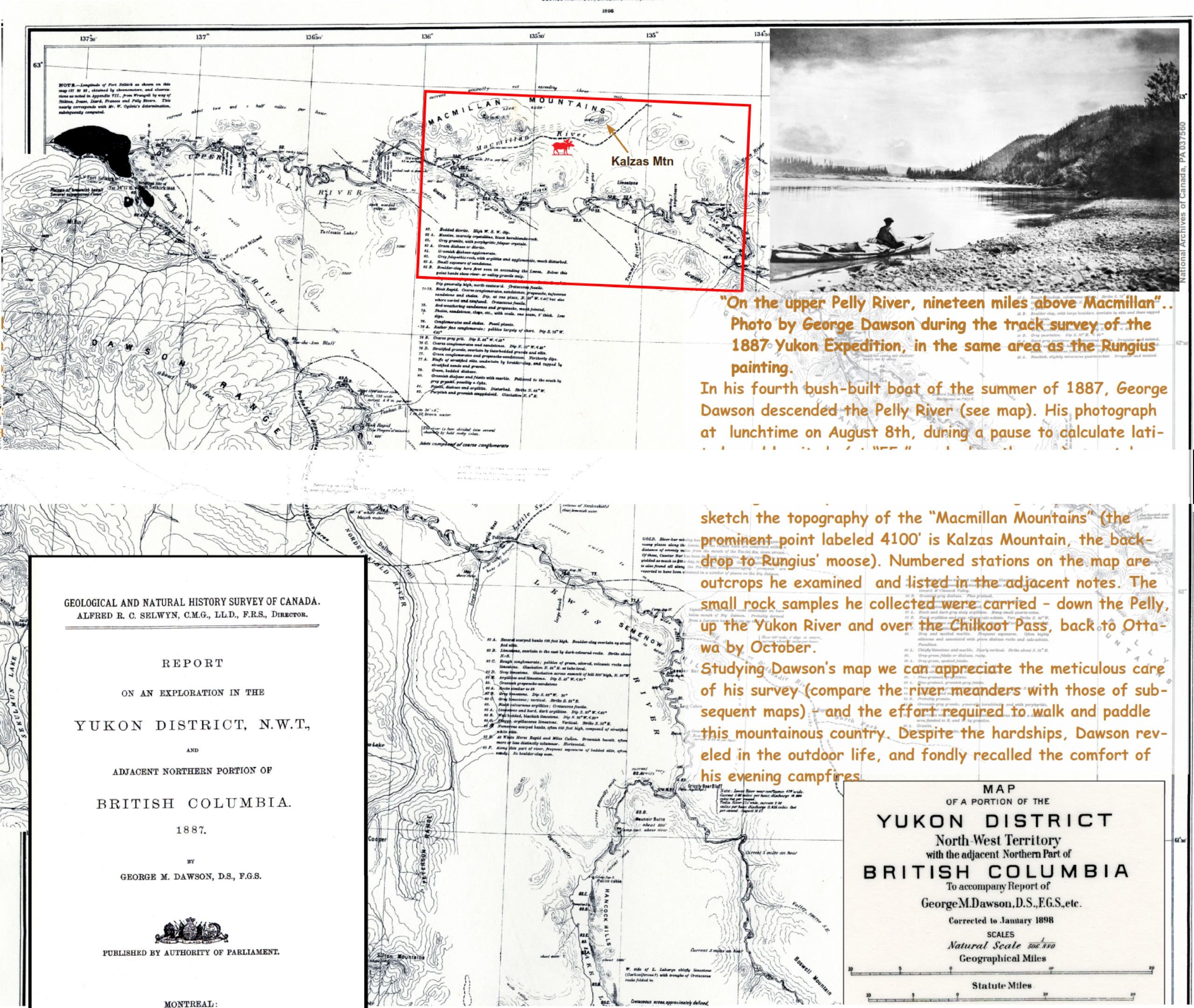
Map 1: Portion of 1887 Map of Yukon District by G.M. Dawson republished in 1898 to meet the demand of those heading for the Klondike goldfields.
Map 1: Portion of 1887 Map of Yukon District by G.M. Dawson republished in 1898 to meet the demand of those heading for the Klondike goldfields.
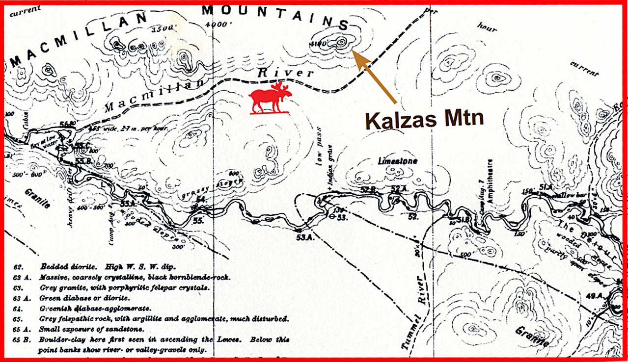
Map 2: Closeup of portion of 1887 map by Dawson for the area near the Rungius painting (moose)
Map 2: Closeup of portion of 1887 map by Dawson for the area near the Rungius painting (moose)
Riverside exposures thus do provide for a broad sampling of regional geology and Dawson’s observations were both careful and astute. However in the absence of complimentary land traverses Dawson could not truly map the geology. This would have to wait until the 1950s.
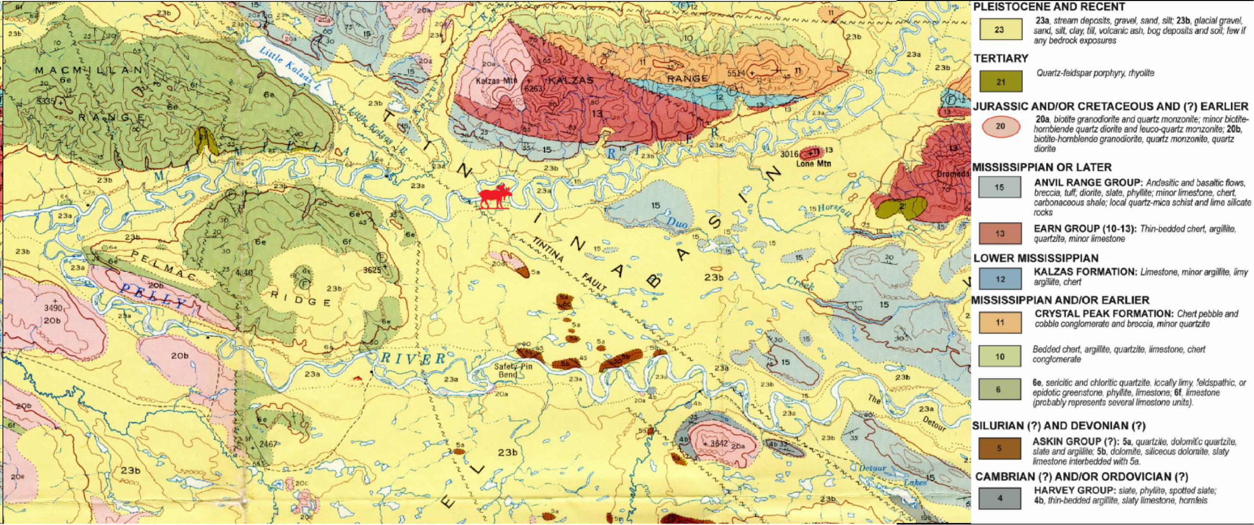
Map 3: Bedrock geological map based upon foot-traverses from camps moved by horse pack-train, 1950-1954.
Map 3: Bedrock geological map based upon foot-traverses from camps moved by horse pack-train, 1950-1954.
This excerpt of Glenlyon map area containing Kalzas Mountain shows the valley underlain by Tintina Fault, separating moderately deformed sedimentary strata (northeast), from more deformed and metamorphosed rocks (southwest).
The bulk of the exposed bedrock on Kalzas Mountain is made up of the Earn Group (mapunits 10-13), composed of westerly-derived upper Paleozoic clastic sediments. Map units 4-6 southwest of Tintina Fault were considered lower Paleozoic based upon their similarity to those in more distant, less metamorphosed areas. The intruding granite plutons are shown in pinks, but their ages were undefined.
During this mapping phase, Cretaceous plutons truncated by the Tintina Fault were found to be 450 km apart, a first measure of the magnitude of right-lateral offset along this fault.
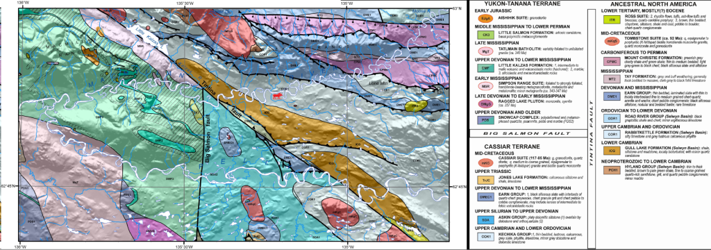
Map 4: Bedrock geology based upon previous and new field work (foot-traverses set-out by helicopter, 2000-2003), with contacts extended beneath Quaternary cover base based upon an airborne aeromagnetic survey (1997).
Map 4: Bedrock geology based upon previous and new field work (foot-traverses set-out by helicopter, 2000-2003), with contacts extended beneath Quaternary cover base based upon an airborne aeromagnetic survey (1997).
The discovery in the late 1960s of stratiform lead-zinc deposits in the Anvil Range (110 km southeast of Kalzas Mountain) led to increased mineral exploration in this region and, over the years, a progressively better understanding of its geology. More detailed bedrock mapping by the geological surveys of Yukon and Canada led to an updated digital geological map (Map 4).
This new interpretation benefited from new age determinations of the rock successions using either fossils or radiometric methods. Regional aeromagnetic surveys allow extrapolation of the bedrock geology through areas of extensive Quaternary cover.
This improved resolution of the geology shows the Kalzas Range to be underlain by formations deposited in the lower Paleozoic Selwyn basin (PCH1, lCG, COR1) and overlying mid-Paleozoic rocks of the Earn Group (DME1) and Mount Christie formation (CPMC).
These units comprise sedimentary rocks deposited along the ancient Pacific margin of North America. They are folded in a tight, southeast-plunging anticline with the oldest unit in the core exposed on the top of the mountain.
Rocks underlying the Macmillan River valley are now considered Cambro-Ordovician, rather than Carboniferous as mapped previously. In the Kalzas Range, these units are imbricated along northeast-directed thrust faults.
Somewhat different rocks are exposed to the southwest of Tintina fault. These form part of the Cassiar terrane; a fragment of the ancestral North American margin that has been displaced ~450 km to the northwest along Tintina fault (Map 2).
The northern tip of Cassiar terrane, now located along the Macmillan River – not far from the point-of-view of the Rungius painting – would be near Watson Lake if post-Cretaceous displacement along the Tintina fault was restored.
Rocks west of the Big Salmon fault present even greater contrast with those of the Selwyn Basin. They comprise metamorphosed sedimentary, volcanic and plutonic rocks of the Yukon- Tanana terrane.
These rocks are interpreted to have formed a volcanic arc west of the ancient continental margin in Devonian to Carboniferous time, developed atop a rifted fragment of the North America.
The Yukon-Tanana terrane then rejoined the west coast margin of North America by early Mesozoic time; the first of many terranes (or micro-plates) to be added to western North America.
The current distribution of terrains in Yukon (Map 2) results from largescale displacements along major strike slip faults such as the Teslin and Big Salmon in Late Cretaceous time (100 to 90 m.y. ago), and final shuffling by the Tintina and Denali faults about 50 m.y. ago.
 George Mercer Dawson