Project Description
NEW BRUNSWICK
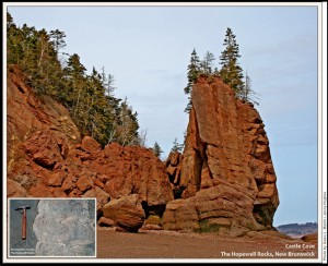
Coastline along Shepody Bay, Bay of Fundy
Seastacks- coastal erosion of early Carboniferous coarse alluvial fan redbeds; marine evaporites & limestones of Maritimes Basin
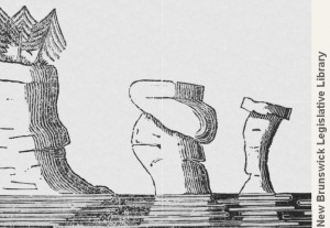
fieldwork by Abraham Gesner
THE SCIENCE
The geological history of the Hopewell Rocks in New Brunswick begins millions of years ago when the province was located near the equator. The rocks of New Brunswick are part of the Appalachian Orogeny, an ancient mountain range stretching from Newfoundland to Florida.
About 355 million years ago (Lower Carboniferous Period), the mountain building cycle was over, and erosion processes dominated. Over the immense span of geologic time, water, wind, and gravity work to erode all mountains, producing in the process huge volumes of gravel, sand and clay.
Near the mountain front, flash floods surged down the steepest slopes, taking with them masses of eroded sediment, the coarsest of which formed gravelly debris (alluvial fan deposits). Further from the high ground, the sediments formed broad alluvial plains with more sorted layers of sand and clay.
The region covered by these terrestrial sediments in Atlantic Canada is called the Maritime basin (map of New Brunswick inserted in the geological map). Over time, the gravel, sand, and clay hardened and became conglomerates, sandstones, and shales. During the Early Carboniferous in the Martitime Basin the paleoclimate was hot and dry (arid).
The sediments contained iron-bearing minerals and when the iron was oxidized, the rocks took on a pronounced reddish hue (redbeds). These sediments were all deposited on land and so are referred to by geologists as continental or terrestrial. From time to time the ocean encroached into the Maritime Basin of southeastern New Brunswick, and these shallow seas were responsible for precipitating limestone beds as well as evaporites such as gypsum, potash and salt.
When the seas last receded about 330 million years ago later during the Carboniferous Period, the cycle of sedimentation began again, covering the limestones and evaporites with younger terrestrial sediments.
The coastal landscape near Hopewell Cape on Shepody Bay (Bay of Fundy) records in its cliffs rocks formed from both marine and terrestrial deposition. However, the seastacks (Hopewell Rocks) are composed for the most part of reddish coarse alluvial fan sediments.
The strata in the Hopewell rocks were deformed by the subsequent Alleghenian Orogeny and as a consequence are now tilted at about 30 degrees from the horizontal. Each layer of sandstone and/or conglomerate, depending upon its degree of cementation and the composition of its clasts, is more or less susceptible to marine erosion. However, the lower portions of the seastacks are subject to the most intense wave and tidal action, resulting in larger masses of rock whimsically perched on somewhat smaller pedestals, hence the alternate name for the seastacks, flowerpots. There are about 20 free-standing seastacks along 2 kilometres of coastline north of Cape Hopewell. The intense marine erosion means that these features are ephemeral, lasting between 100 and 250 years from when first separated from a spur of the coastal cliff, before collapsing into the Bay of Fundy.
At the end of the southernmost beach, rocks of the Hopewell Cape Formation overlie limestone of the Lime-Kiln Brook Formation. Limestones contain fossilized stromatolites. These cabbage-head-shaped structures were formed by layers of primitive algae in a marine coastal environment.


 Abraham Gesner