Project Description
ALBERTA
Northern Alberta Along N. Saskatchewan River Near Edmonton
Upper Cretaceous stratigraphy; the “Belly River” problem; coals
fieldwork by Joseph Tyrrell
THE SCIENCE

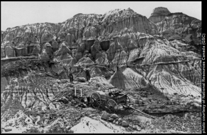
Figure 1: The badlands of southern Alberta,collecting ground for dinosaur remains.Sections of the fossil skeletons are wrappedwith strips of burlap dipped in fluid plaster,then packed in boxes for shipment to Ottawa.Photographer: C.M.Sternberg (1914)
During the period that J.B. Tyrrell worked for the Geological Survey of Canada, field geologists employed by the survey were often sent to vast, largely unmapped and uninhabited regions to map the geology, catalogue natural resources, and to determine the suitability of the area for settlement.
To fulfill these tasks, field geologists required a broad range of skills and knowledge, but above all, they had to cover large areas of wild and sometimes difficult terrain in all kinds of weather, sometimes living off the land to supplement their supplies.
To achieve this, field parties had to travel fast and light, taking with them only the essentials for their work and a bare minimum of comfort. Tyrrell learned these skills under the tutelage of G.M. Dawson, a competent field geologist and a man of legendary endurance.

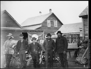
Figure 2Photograph of Dr.J.B.Tyrrell’s survey party, with Tyrrell at far. G.M. Dawson is in middle.Left, Red Deer, Alberta. Photographer: J.B.Tyrrell (1886)
Tyrrell took to the life of a field geologist, enduring the hardships and enjoying the romanticism. In a letter home to his father, he wrote: “you must not consider that I am enduring hardships. I am not in my blankets five minutes before I am asleep and there is a charm about this life that for a young man is not in any other”.
In the period that Tyrrell worked, there were often no base topographical maps on which to overlay geological observations, so field parties had to make their own as they went along. This was a time-consuming process.
As a result of this added duty, aside from the typical field tools of a geologist, consisting of a rock hammer and hydrochloric acid, Tyrrell had to also take the instruments for surveying, which at that time consisted of a prismatic compass, odometer to be attached to the wheel of the buckboard, tape line, watch, aneroid, sextant and artificial horizon. To carry all this gear, plus geological samples, camping gear, and basic supplies, Tyrrell often utilized a horse-drawn wagon, or sometimes a canoe.

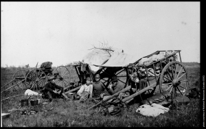
Figure 3: Lunch stop at Silver Creek showing Red River cart, Manitoba (Four men seated withtwo Red River carts and a horse-drawn wagon).Photographer: J.B.Tyrrell (1887)
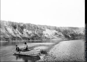
As his career progressed, Tyrrell increasingly relied on canoes to undertake fast and light explorations along waterways through remote northern areas.
The Interpretation
Considering the exploratory nature of the work, and the difficulty of travelling across the rolling prairie and wooded regions, Tyrrell’s map and geological interpretations (Tyrrell, 1887a, 1887b) are remarkably accurate, if lacking in local detail.
He was not starting completely from scratch, however, as Dawson and R.G. McConnell had largely worked out the upper Cretaceous stratigraphy exposed in southern Alberta. Tyrrell would have been exposed to the various rock formations and benefitted from Dawson’s knowledge and tutelage the previous summer.
Tyrrell also had the benefit of the geological and geographic observations made by James Hector of the Palliser expedition (1857-1860). He used the Palliser expedition map as his base map, and so the major features of the area were not entirely unknown to him.
Tyrrell is often (erroneously) credited with discovering the coal seams in the Drumheller area, but Hector had reported burning lignite (coal) seams in the Drumheller area some 25 years earlier. In most respects, Tyrrell’s geological map is essentially correct.
There are, however, some significant errors in the northeast quadrant, particularly involving the distribution of the Edmonton, the Pierre (Bearpaw), and the Belly River series beds. Tyrrell placed all of the Belly River series beds that outcrop along the North Saskatchewan River within the Edmonton series, an understandable, but significant error.
He conceded that his favoured interpretation may have been incorrect, and notes in his report: It is not at all improbable, that the discovery of fossils may at any time show that the line of the bottom of the Edmonton series has been drawn too low… In other words, Tyrrell suspected, based on their character, that the rocks occurring along the North Saskatchewan River between Edmonton and Victoria were, in fact, those of the Belly River series, but because the shales downstream of Victoria were identified as those of the Pierre series and dips in the area were essentially horizontal, he was forced to place the beds within the Edmonton series.
The ultimate source of Tyrrell’s error can be traced back to one of the few errors made by George Mercer Dawson, which has come to be known as the “Belly River problem“.
Because Dawson did not recognize the marine shales of the Pakowki Formationbetween the marginal to nonmarine beds of the Belly River Group and the Milk River Formation, he included all of these units within his Belly River series. To deal with the missing Belly River series along the North Saskatchewan River, Tyrrell looked to the south.
In the eastern portion of the map area, he had mapped rocks of the Belly River series along the Battle River and Ribstone Creek. Although the orientation of bedding was essentially horizontal along the North Saskatchewan River, Tyrrell drew a fold closure so that the Belly River series did not outcrop this far north.
This fictional anticline was to influence geologists working in Alberta until Allan (1918) correctly resolved the stratigraphy, and determined that the structure along the North Saskatchewan River was a monocline, and not an anticline.
References & Suggested Reading
Allan, J.A. 1918. Sections along North Saskatchewan River and Red Deer and South Saskatchewan rivers, between the third and fifth meridians. In: Summary Report of the Geological Survey of Canada 1917, Part C, pp. 9-13.
Inglis, A. 1978. Northern Vagabond: the life and career of J.B. Tyrrell. McClelland and Stewart Limited, Toronto, Ontario, 256 p.
Martyn, K. 1993. J.B. Tyrrell: Explorer and Adventurer. University of Toronto, Governing Council, University of Toronto Library, Toronto, Ontario, 72 p.
Russell, L.S. 1988. The First Fossil Hunters. Alberta: Studies in the Arts and Sciences, v. 1, pp. 11-16.
Spalding, D.A.E. 1988. The early history of dinosaur discovery in Alberta and Canada. Alberta: Studies in the Arts and Sciences, v. 1, pp. 17-26.
Tyrrell, J.B. 1887a. Geological map of part of northern Alberta and portions of the Districts of Assiniboia and Saskatchewan, North West Territory. Geological Survey of Canada, Map 249, scale 1:506 880.
Tyrrell, J.B. 1887b. Report on a part of northern Alberta and portions and districts of Assiniboia and Saskatchewan, embracing the country lying south of the North Saskatchewan River and north of lat. 51°. 6’, between long. 110° and 115° 15’ west. Geological Survey of Canada Summary Report for the year 1886, 176 p.


 Joseph Tyrrell