Project Description
NORTHWEST TERRITORIES
Great Slave Lake Area
The Slave Craton, Archean Core of North America; world’s oldest rocks; Greenstone Belts; Wopmay Orgogen & Ancient Tectonics
fieldwork by Paul Hoffman
Slave Craton – THE GEOSCIENCE
Initial geological and other scientific inquiry
In 1820 Sir John Franklin embarked on his first expedition, across the vast wilderness of the Canadian North West through the region of Great Slave Lake. Midshipman Robert Hood, of the same expedition captured an image with a small pencil sketch, of John Franklin’s intrepid group of explorers crossing a small body of water, called Prosperous Lake, located just north of Great Slave Lake.
The drawing shows a small flotilla of canoes, some under sail, passing a large prominent rock along the shores of the lake. The sketch illustrates this with fine detail capturing the unexplored topography, and the mode of transportation utilized by the expedition (birch bark canoes). Robert Hood made many drawings and watercolour paintings throughout the trip, which became valuable documents for reference used by Sir John Franklin for his narrative published in 1823. Hood’s primary role on the trip was scientific in nature. He served as the expedition’s ethnographer, botanist, ornithologist, geographer, surveyor, draughtsman and illustrator. He made the first magnetic survey of the Northwest and studied the aurora borealis.
It was almost eighty years later, when another expedition was embarked to explore the Great Slave Lake region, this time with the purpose of understanding the bedrock geology. In 1899 Robert Bell of the GSC assisted by J. Mackintosh, conducted reconnaissance surveys of the shoreline of Great Slave Lake. These early efforts were incorporated in a compilation map published in 1922. Metamorphosed volcanic rocks are shown in green.

Figure 1: Portion of GSC compilation map 1585 published in 1922. Red arrow points to Prosperous Lake.
In the late 1930’s A.W. Joliffe of the GSC started his more detailed geological studies of the Great Slave Lake area, and was the first to identify the significant mineral potential to be found there. In 1946, the work of Joliffe on the Prosperous Lake map-sheet was published (Map 1). Joliffe left the survey in 1950 to take up a position teaching at Queen’s University, where he became a leading authority on economic geology.
")
Figure 2: Portion of GSC geological map of Prosperous Lake mapsheet by A.W. Joliffe (1946)
Modern Interpretation
The rocks in the vicinity of Prosperous Lake form part of the Slave Craton, one of several fundamental Precambrian building blocks of the North American continent. Cratons are very large and generally stable land masses made up of thick continental crust and uppermost mantle that form the core to continents.
")
Figure 3: Schematic map of PreCambrian cratons and orogens from Eyles & Miall (2007)
The Slave Craton was originally part of a late Archean landmass (“Slavia”) before it broke-up due to the onset of continental drift. The Slave craton is very old and can be considered a well traveled fragment of crust, indeed the Slave Craton can be seen as the initial nucleus around which all the rest of North America has accreted. The world’s oldest known rocks, the Acasta Gneiss, dated at 4.03 Ga (billion) years, occur in the Slave Craton and outcrops of similar rock occur just 70 km east of Prosperous Lake. The age of the Earth is generally accepted to be around 4.6 Ga.

Figure 4: A simplified geological time chart showing the approximate age of the Prosperous Lake greenstones (red arrow). Red asterisk marks the very oldest known rocks on Earth, also found on the Slave Craton. Blue arrow points to the time of formation of the Wopmay Orogen. (see Figure 7 below).

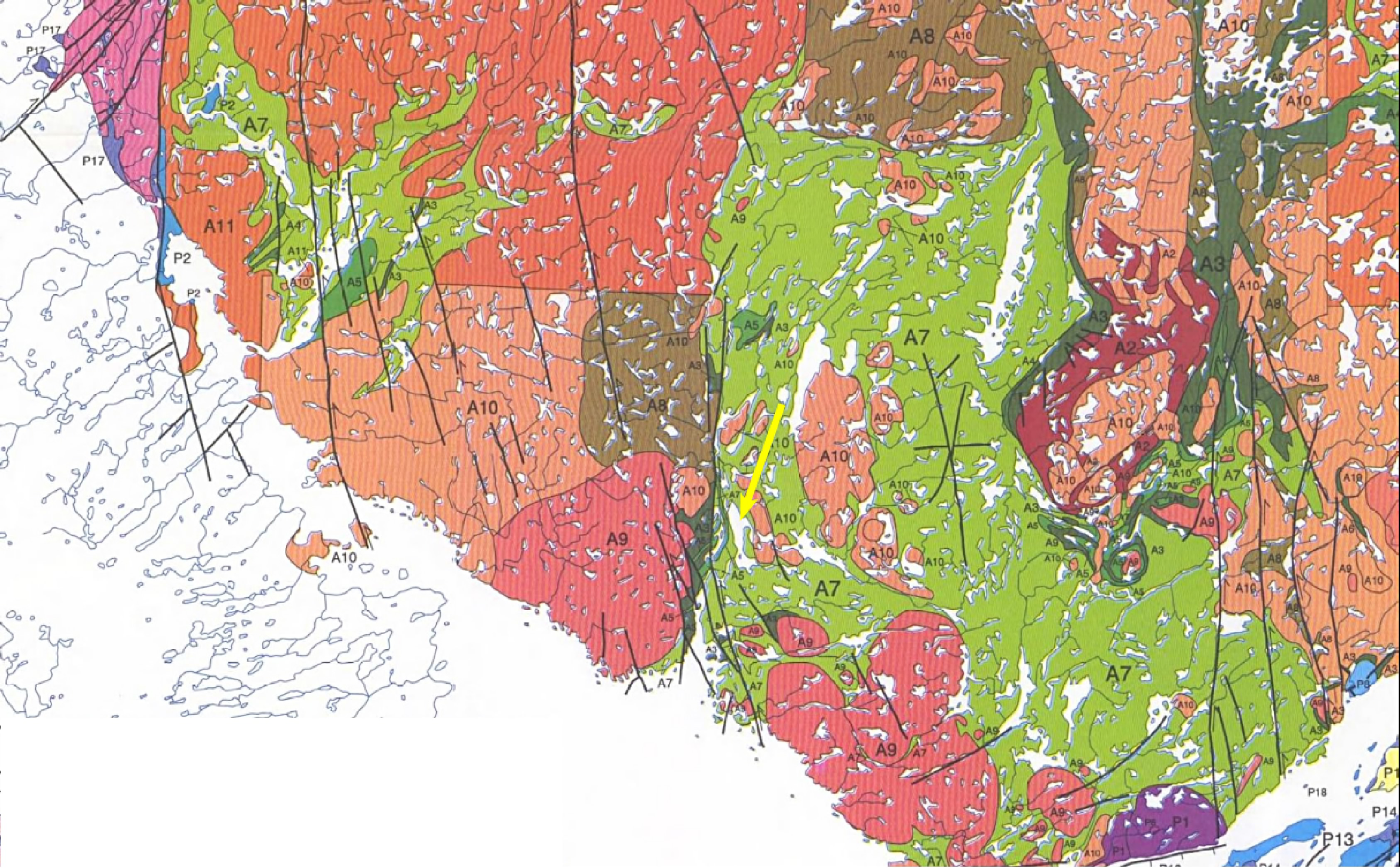
Figure 5: Portion of GSC geological map by Paul Hoffman et al. in Open File 2559 published in 1993. Most of the mapping done in the immediate Prosperous Lake area (yellow arrow) was done by J.B. Henderson of the GSC.
………. In the immediate vicinity of Prosperous Lake, the rocks are predominantly metamorphosed and deformed oceanic volcanics (basalts) and associated deep-water sediments (turbidites) of Archean age (~ 2.8 Ga). Outcroppings of similar ancient volcanics occur over vast areas and these tracts are generally referred to as greenstone belts, and are a common host for gold deposits. This interpretation of the Lake Prosperous rocks has been consistent over the years, as is well-illustrated in the maps seen in Figures 1, 2 and 5.

Figure 6: Schematic map of Slave Province with its ancient basement and greenstone belts emphasized (Figure 4.8 of Eyles & Miall,2007).

Figure 7: Diagrammatic cross-section showing the deformed rocks of the Wopmay Orogen that developed on the western margin of the Slave Craton when the Hottah Terrane and Slave Craton collided about 1.7 Ga ago (Figure 4.15C of Eyles & Miall,2007).
Paul Hoffman started mapping in the Great Slave Lake area (and north) in 1969, and subsequently spent at least 11 field seasons in the region. His contribution, along with many co-workers and graduate students, is a detailed understanding of the geology of the East Arm of Great Slave Lake, and of an ancient collision zone at the western edge of the Slave Craton known as the Wopmay Orogen.
The Great Slave Lake region of Canada continues to be a frontier for discovery, whether it is in earth science, adventure travel, archeology or as a muse for art and poetry.
 Paul Hoffman